 Montour Railroad
|
|
Partridge Mine Here is Bob Ciminel's report on the Partridge Mine After passing the siding for Jean Mine, the next eastward station on the Montour Railroad was North Star Junction at Milepost 10.7 (Trail Milepost 9.8). This was the point where the 1914 Mifflin Extension to a connection with the Union Railroad originated. However, prior to 1914,the Montour Railroad extended its line two miles from Imperial to North Star in 1879 to reach the coal reserves on the Partridge Farm on the South Fork of Montour Run. Partridge Mine at North Star represented the Montour Railroad's first extension from its terminus at Imperial. Partridge was a large mine, and if the mine maps I have are correct, was still producing coal into the 1950s, although it may have been as a strip mine. Records show that Aloe Coal was stripping coal at Partridge in 1956. Partridge was a hot bed of activity during the Great Coal Strike in 1928 and a lot of violence involving the Coal and Iron Police, as well as strike breakers occured at North Star/Santiago. Partridge is still leaving its mark on the area. It is a source of acid mine drainage into the North Fork of Robinson Run. In June 1813, Thomas Partridge took title to 206 acres in North Fayette Township, and called the parcel Partridge Nest in accordance with land ownership requirements existing at that time. Partridge’s land contained an outcrop of the Pittsburgh coal seam. The Montour Railroad was extended to reach those reserves as the economically mineable coal at the Imperial Coal Company’s Cliff and Montour mines, which were opened in 1878, began to decline. (The Partridge Mine would eventually extend northward and southward and become one of the largest underground mines on the Allegheny/Washington County border.) Although the Partridge Mine was originally opened by the Imperial Coal Company, by 1898 it was owned by the Morgan, Moore & Baine Company, headquartered in Cleveland, OH, which also owned the Margerum Mine. Ownership by MM&B seemed to be a prelude to the organization of the Pittsburgh Coal Company, which took over the Imperial Coal Company, its mines and the Montour Railroad between 1899 and 1900. Once the mine was taken over by the PCCo, colloquially known as “The Coal Company,” production and efficiency improvements began almost immediately. (A major impetus in creating the Coal Company was to bring the hundreds of marginal mining operations under one roof and eliminate the smaller independent mines that were driving down the price of coal.) In 1903, the Coal Company installed an 18-foot diameter fan at Partridge to improve ventilation, and in 1913 ran a power line from the Partridge Mine over to the Margerum Mine. Production in 1913 was 572,295 tons of coal, which was mined for about $1 per ton. By 1914, the main entries were extended over 9,000 feet, or almost two miles. By 1915, Partridge Mine had four electric locomotives, 29 electric mining machines and 10 pumps to remove water from the mine. The power house had seven boilers and generated enough electricity at 500 volts DC to supply its own power and Margerum Mine. North Star also went through several changes over the years, some good and some bad. Although the town was called North Star, the post office was called Tyre. After the SpanishAmerican War, the town renamed itself Santiago, although locals called it San Diego. The miners who worked at Partridge called the town “Hell’s Half Acre” because of the violence that went on during the great coal strike in 1928. In the early 1900s, Partridge miners made about $13 a week for a six-day week and about 22 cents per yard for non-production work, such as cutting breakthroughs between rooms. The maps included below provide more details about Partridge Mine and its history. The Partridge tract is shown on the lower left. This is a 1914 map produced by Allegheny County to show the original landowners who were awarded Warranty Deeds when William Penn conveyed his ownership of Pennsylvania to the Commonwealth legislature. 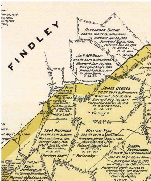 This is an 1876 map showing the North Star Post Office and the Steubenville Pike. At this time, the town of Imperial did not exist and the area was known as Valley Church. By 1878, the Montour had reached Valley Church and was extended to North Star the following year. Note that in 1876 the stream was called Montours Run. 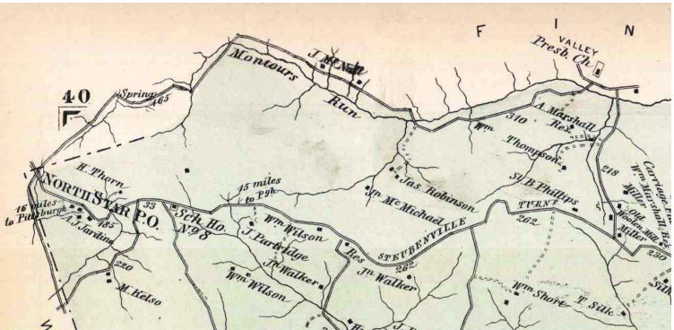 Partridge Mine and the Montour Railroad are shown in this 1907 map of Allegheny County. The orientation of the mine entrance is not totally accurate. The main entries extended to the southwest, not due east as shown on this map. The dotted line is an indication of where the Pittsburgh coal seam outcropped on the hill sides and stream valleys. 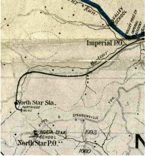 Schematic of the Partridge Mine looking north. The tipple and Montour tracks are on the left, with the power house shown as a dark rectangle below the tipple. The mine entries are at bottom center and extend under the Pike 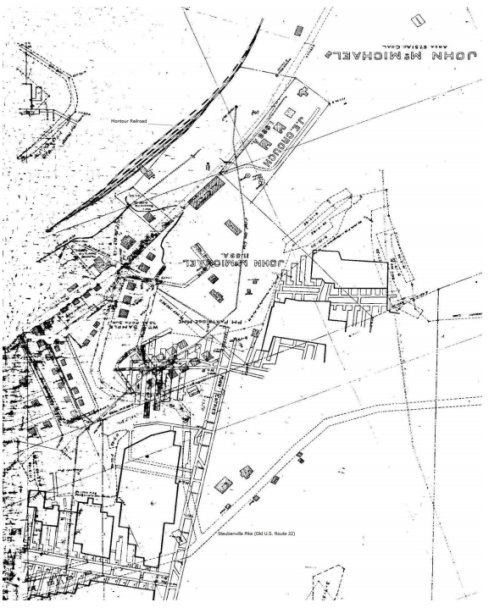 This map is from an Operation Scarlift Report showing the extent of the Partridge Mine when it was abandoned. It also shows two of the drift entries into the mine at Potato Garden Run. The numbered spot on Half Crown Run is a location where drainage from the mine reaches the surface. 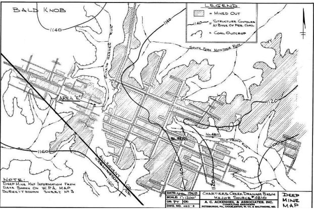 This WPA mine map from the 1930s also shows how large the Partridge Mine was. The mine was still in production, or had only recently shut down, at this time, as evidenced by the Montour Railroad spur still extending to the mine tipple. 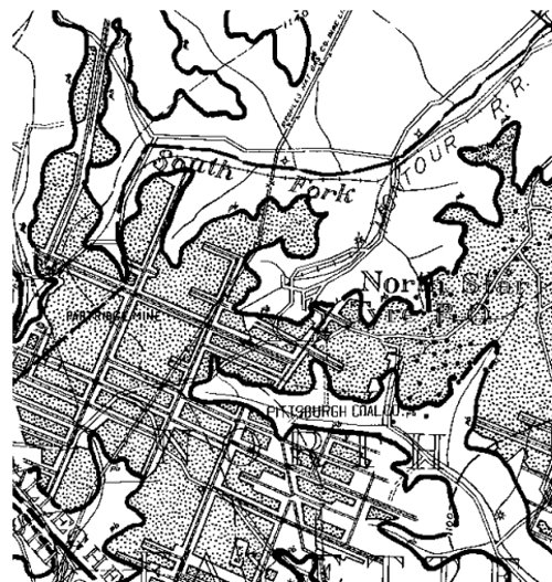 A 1939 aerial photo (pennpilot) of the old Partridge Mine. The tipple has been torn down and the railroad spur looks abandoned. Note the potholes on the left showing that the mine workings had move westward. 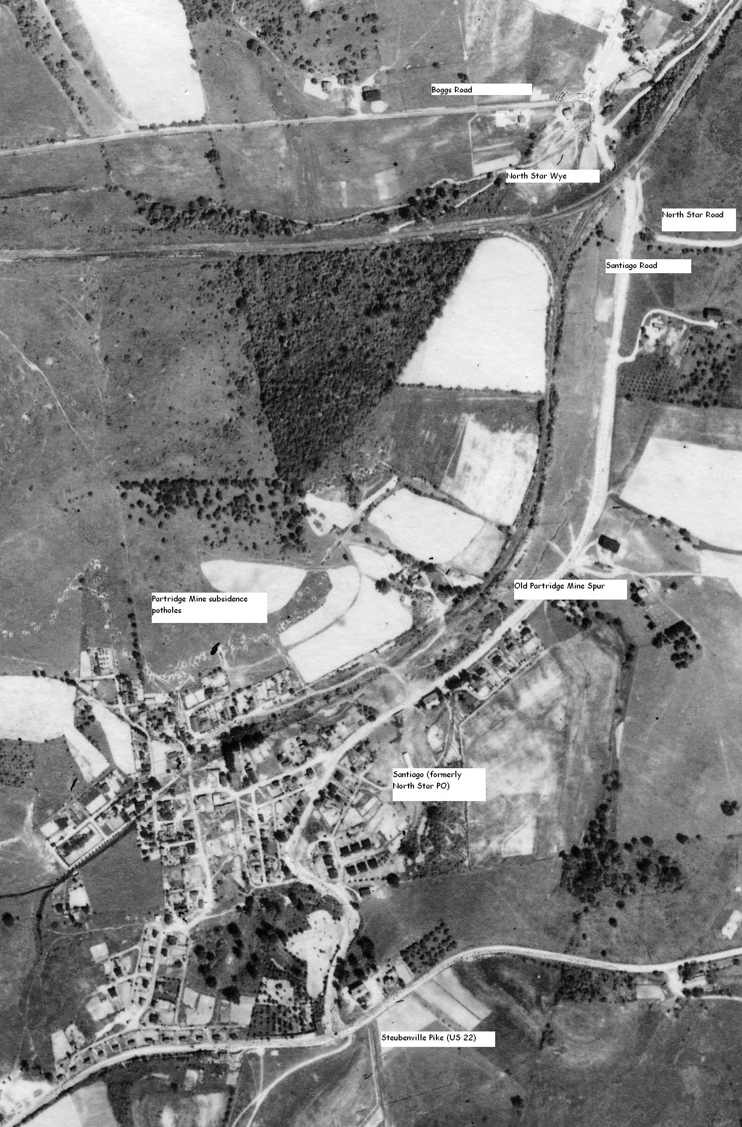 |