Bill Crane provides a set photos detailing the area of the Montour
Railroad near McMurray around Mile post 33. This section of the Montour is
now part of the Arrowhead trail.
This bridge is about half a block from 19 and
Valleybrook Rd
Here is an old tie decaying near the bridge.
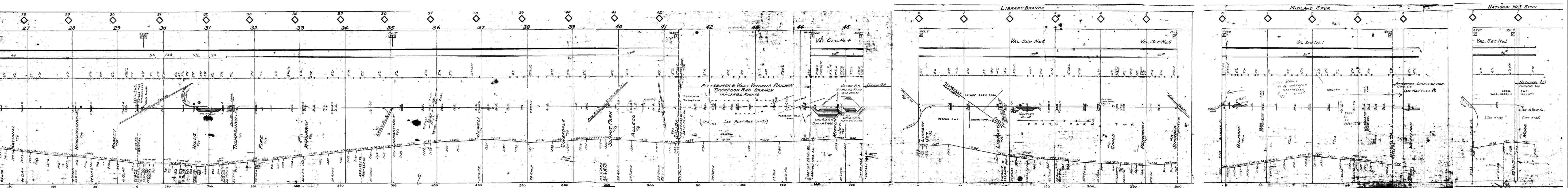
This overpass is shown on the
track chart as a siding in McMurray. I'm not sure what the siding was
used for. The stream underneath in the pictures flows into Brush Run. This
overpass is about 1/4 mile away from the bridge shown above.
This is a top view that shows the siding. This
is looking toward Rt 19.
View toward Valleybrook Rd. This is the narrow
Bridge that crosses brush Run.
This is the underside of the siding overpass.
Bebout Rd. Tunnel. This tunnel was
built in 1913.
The date of 1913 is etched above the tunnel
portal.
This is a picture of an old cement foundation. The track chart shows a
tool house, (approx. location near previous bridge siding). I don't know
if you can see it, but there was a rail imbedded in the foundation..! A
better picture needs to be taken when the snow melts.
Part of my stupid dashboard, and trail overpass
over McMurray Road. I believe this overpass was constructed when the
McMurray/Valleybrook roads were re-aligned about 10 years ago.
This picture shows a piece of skinny rail -
probably 90# stuck in snow and mud.
Old roadbed facing opposite way (away from
siding overhead).
 Montour
Railroad
Montour
Railroad 


