Montour Railroad
Mileposts
Bridges
and
Tunnels
History
Maps
Roster
Mines
Links
Gallery
Working on the Montour
Schaeffer Stories
Sposato Stories
Employees
Railroading 101
|
|
Bridges and Tunnels of the
Montour
A Study By Bryan Seip
| Tunnels
of
the Montour |
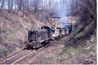
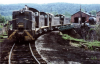
The Montour had 4 tunnels bored on
its main line - but only 3 were in existence at any 1 time.
Tunnel #1 was the 4th one bored, while Tunnel #2 was
probably the 1st, in 1913. Seven years later, #2
didn't exist except as a memory and a deep cut. The 4
tunnels were known by 7 different names - and one of those
had two spellings and then shared its name with another
tunnel that doesn't even belong to the Mighty M.
Another with two names probably shouldn't have used either
one and the name of the land-owner where it was built was
never mentioned. Three were curved and only one was straight
and one crested a hill in the middle of its bore, meaning
train crews had to transit under power in either direction -
thus running in smoke and exhaust fumes. (How long can you
hold your breath?? - Not long enough at 10 MPH or less.....)
two were considered wet and only one was dry. The shortest
was 235 feet and the longest 623. - Bryan
Seip
|
Jeffreytown |
Jefferytown
Read Bryan Seip's full report here.
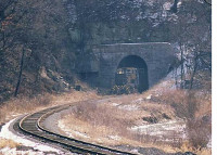
Jefferytown tunnel has 2 names. RR aficionados refer
to it as Jefferytown, while the Trail community calls it
Enlow. As Bob Ciminel suggests, maybe neither is
correct, as the tunnel was bored on the granted property of
Robert McMin.
Bob calls it Montour Tunnel #1 as a reference, as it is the
first tunnel heading east from Montour Junction.
However, it was the 4th tunnel bored on the Montour main
line.
Three were bored during construction of the Mifflin
Extension in 1913-14 and this one was constructed as part of
the realignment project from Cliff Mine to Imperial in 1926.
The tunnel eliminated almost a half-mile loop of main line
that followed Montour Run around the rocky hillside and also
eliminated Milepost 9, which was included on that track
segment. Thus, MP 8 & MP 10 are only about a mile
& a half distant. This tunnel was the only straight bore
on the Montour. The other 3 were all curved. It also
has had interior lighting installed by the Trail Council to
make it an easier transit for Trail users. At 575
feet, it was dark, and exhaust fumes & smoke were a
challenge to train crews. (National Tunnel also received
interior lighting this summer, while Peacock Tunnel was
daylighted by 1920 and Greers Tunnel is much shorter, so
does not need lighting.)
Bob Ciminel:
 I'll call
it Montour Tunnel No. 1 for starters, but the first tunnel
on the Montour has so many different names it confuses a lot
of folks. Let's start from the beginning before the
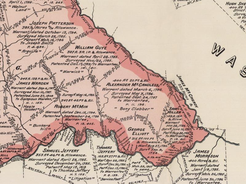
Montour even existed. Plates 27 & 28 of the Warranty
Atlas of Allegheny County, which shows the original owners
of land grants in the county, show the spit of land where
the tunnel is located as being owned by Samuel
Jefferey. This would be on the original alignment of
the right of way before the tunnel was built in 1924.
The land where the tunnel actually went through the ridge
was owned by Robert McMin. You can see that on the
attached map. Samuel Jeffery's deed goes back to 1785,
while Robert McMin's was recorded in 1784. So, that
would give precedent to calling it McMin Tunnel. I'll call
it Montour Tunnel No. 1 for starters, but the first tunnel
on the Montour has so many different names it confuses a lot
of folks. Let's start from the beginning before the
Montour even existed. Plates 27 & 28 of the Warranty
Atlas of Allegheny County, which shows the original owners
of land grants in the county, show the spit of land where
the tunnel is located as being owned by Samuel
Jefferey. This would be on the original alignment of
the right of way before the tunnel was built in 1924.
The land where the tunnel actually went through the ridge
was owned by Robert McMin. You can see that on the
attached map. Samuel Jeffery's deed goes back to 1785,
while Robert McMin's was recorded in 1784. So, that
would give precedent to calling it McMin Tunnel.
If we move ahead to 1906, the Carnegie Quadrangle of the
USGS topographic map shows the area around the tunnel
labeled "McMinn." There's no mention of the Jefferys
or any place called "Jefferytown." The community of Enlow
doesn't exist either. Montour Railroad public timetable No.
16, which went into affect on April 25, 1915, lists the
station as "Jefferytown." It's also listed that way on
passenger tickets. The 1940 Montour Railroad employee
timetable does not list the tunnel; however, the 1962
Montour track chart identifies the tunnel as "Jefferytown,"
without the second "e" in the name.
Gene's book refers to the tunnel as "Jeffrey Town" in
the chapter titled "Montour Junction to Imperial
Realignment" on Page 66. The "Bridges and Tunnels of
Allegheny County" website says the "official" name of the
tunnel is either "Enlow" or "Jeffrey Town."
So here's my argument: The name "Jeffery" is only mentioned
in the Warranty Atlas and is never seen again on any
official documents. The "McMins" actually owned the
land the tunnel was bored under. The names "McMin" and
"Jefferey" have been spelled "Jeffrey" and "McMinn" over the
years. The Montour railroad timetables and track chart
list the station at the west end of the tunnel as
"Jefferytown" and the east end is called
"Enlow." The timetables list stations from west to
east, in the direction of train superiority. So I will
refer to it as the "Jefferytown Tunnel" until someone can
provide solid evidence to the contrary.
|
|
Peacock |
Peacock
Read Bryan Seip's full report here.
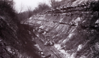
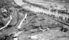
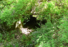
Very little hard information can be found about Peacock
Tunnel - bored through a hillside between Primrose and
Southview during the 1913 Mifflin Extension project - east
of MP 21. It was probably the first tunnel built on the
Montour. Like the others at that time, it was built with a
timber & wood lining. However, this hill was very wet
and the ground was unstable and water and rocks falling
inside the tunnel hampered train operations almost from the
very beginning. As the way to rectify these problems, it was
decided to daylight the tunnel and make it a deep, but open,
cut. The tunnel does not appear on the 1920 track charts, so
daylighting took place before that date.
Tim Sposato has said that he heard comments from some of the
"old hands" on the track gangs that indicated the tunnel was
only in existence for about 5 years - which would put the
daylighting about 1918-1919. But again, no hard
evidence and even the "old hands" would have had more than
55 years between the end of the tunnel and Tim's employment,
so many of the comments about the tunnel may have been
passed down a generation or two. Tim tells us Jim Lane
talked about seeing timbers sitting on the side of the cut
when he started working on Montour train crews in 1936.
This hillside still has water and rockfall
problems. You may have seen a story in the latest
Montour Trail newsletter about trail crews recently working
in Peacock Cut cleaning dirt, debris and rocks out of the
drainage ditches. Occasionally rocks will still fall
off the sides of the cut and end up on the trail surface.
Walking the cut & checking out the terrain & maps,
it looks like the tunnel could have been in the 600 foot
range, with a curve in its bore. It is hard to tell what
distance the right-of-way might have been cut into the
hillside before the portals were installed (similar to those
at National Tunnel) and as there is no indication where the
portals were actually located, this is an educated guess.
Peacock is the only Montour tunnel with only one name -
perhaps due to the short time it was in existence - but I
bet those early train crews and track gangs had a few other
interesting names they called this tunnel. - Bryan
Seip |
|
|
|
|
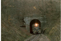
National |
National
Read Bryan Seip's full report here.
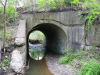
This tunnel was known by three different names. Most
railroad features are named for a nearby landmark or land
owner where a structure is built. This tunnel was called
National - for the nearby National Coal Company mines that
the Montour Railroad serviced. It was also known as Bishop -
for the near-by community of that name, and as McConnell -
for the farm land on which it was bored.
This was the longest of the Montour tunnels, at 632
feet. The railroad grade was uphill from either
direction into the tunnel and it crested the top of the hill
inside the tunnel. Thus, with a train stretched out
behind them, the train crews had to keep full power as
they transited the tunnel, engulfed in smoke or exhaust from
the locomotives. By the time half their train's weight was
over the crest and they could throttle back, the engines
would usually be outside the tunnel portal.
Known as a wet tunnel, water dripping from the ceiling still
presents a problem, as winter freezes create an impressive
crop of icicles and ice mounds inside the tunnel. Safety and
visibility for Trail patrons was addressed by two projects
in recent years. The floor was paved with asphalt in
2008 and interior lighting was added in 2012. - - Bryan
Seip |
|
|
|
|
Greer |
Greer
Read Bryan Seip's full report here.
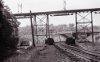
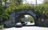
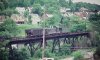
The fourth tunnel on the Montour Railroad was Greer Tunnel.
The shortest of the Montour tunnels at 235 feet, it goes
through the sharp ridge-line above Chartiers Creek on the
Peters Township side of the creek. An earlier tunnel was
bored through the same ridge in the late 1800's, at a lower
level, to carry the PCC&StL (ex-PRR/Penn
Central/Conrail/now-Pittsburgh & Ohio Central) on its
Washington Branch. As the land around this tunnel site
was owned by the Bell families, it was called Bells Tunnel.
When the Mifflin Extension was built in 1913-14, the Montour
bored their tunnel at a higher elevation to be able to cross
over the PRR line on the east side of the ridge. It is the
only tunnel on the Montour to have bridges outside both
portals, with the spectacular view of Chartiers Creek on the
west and the through-truss over an active railroad outside
the east. A nearby land owner named Greer was used to
indicate the newer tunnel.
Some confusion over the names of the two tunnels remains,
with some topo maps mis-labeling the earlier tunnel as Greer
and the later tunnel as Montour Tunnel. Timetables
from the PRR show their tunnel as "Bells" - but the current
operators of the line - Pittsburgh & Ohio Central's
Arden Branch - call this tunnel "Greer", perpetuating the
confusion. Thus, while some other tunnels on the Montour
were known by two or three separate names, Greer Tunnel had
its name at two different locations.
The last railroad operations over this section of the
Montour were at the end of 1980. Rails were pulled up
and the line abandoned within a few years. Greer
Tunnel and the bridges were closed and lay dormant until the
Montour Trail Council re-built and opened this section of
trail in 2008, eliminating an important "missing link" to
the Arrowhead Trail in Peters Township.
Bryan Seip |
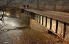
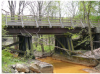
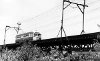
| Bridges
of
the Montour |
|
|
|
|
Engine House |
Car Yard |
Groveton |
Shop Loop |
MP
2-3 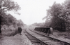
|
MP
3.8 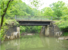
|
MP
4.0 
|
MP
4.2  |
MP
4.8  |
MP
5.0  |
MP
5.2 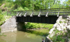 |

Nelson Industries |
MP 6.7 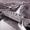 |
MP 7.1 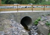 |
MP
8.2 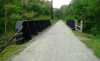 |
MP
8.3 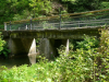 |
MP
8.4 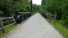 |
MP
8.5 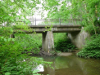 |
MP
9.8 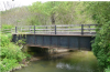 |
MP
9.9  |
MP 10.1  |
MP
10.4  |
MP
10.5 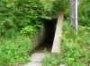 |
MP
10.7 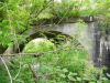 |
MP 10.8  |
MP
11.8 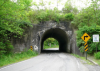 |
MP
15.5  |
MP
15.6 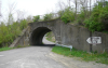 |
MP
16.0 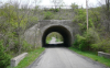 |
MP
16.4 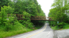 |
MP
17.2 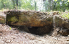 |
MP 17.6 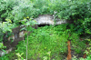 |
MP
19.5 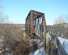
McDonald Viaduct |
MP 19.5
McDonald Txfr
|
MP
21.0 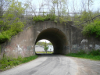 |
MP
22.7 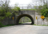 |
MP 22.8  |
MP 23.1  |
MP 23.4  |
MP 23.7  |
MP
24.0 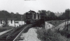 |
MP
24.5 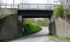 |
MP
25.3 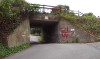 |
MP
26.2 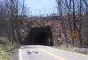 |
MP
27.3 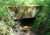 |
MP 27.5
 |
MP
28.0 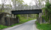 |
MP 29.1
 |
MP 29.2
|
MP
29.5  |
MP
30.1 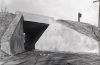 |
MP
30.6  |
MP
30.8 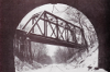 |
MP
31.5 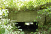 |
MP
31.7 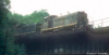 |
MP
32.3 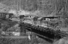
|
MP
32.4 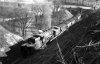 |
Pittsburgh Railways
Interurban Bridge |
Pittsburgh
Railways
Thompsonville Bridge
Part 2 |
MP
32.6 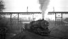 |
MP
33.1 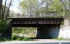 |
MP
34.1 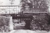 |
MP
34.7  |
MP34.8
 |
MP 35.7 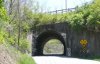 |
Library Viaduct |
MP
36.5 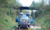
Memories |
MP
38.1 
Memories |
MP
38.8  |
MP
39.2 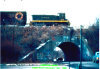
Logan Tunnel Vandalizsm
|
MP
40.7  |
MP
41.2  |
MP 41.3 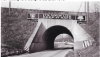 |
MP 41.4  |
MP
42.0 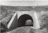 |
MP
42.1  |
|
|
|
|
WESTLAND
BRANCH
|
|
|
|
Westland
2.7  |
Westland
2.9 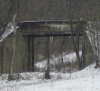 |
Muse
Branch 0.6 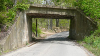
|
|
|
|
|
|
| LIBRARY
BRANCH |
MP
2.0 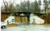 |
MP
2.9 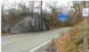 |
MP3.0
 |
MP
3.1 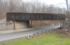 |
MP
3.7  |
MP
4.0 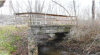 |
MP
4.3 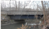 |
MP 4.5  |
MP 5.2  |
|
|
|
|
 Montour Railroad